


Explore the amazing trails around crystal
Summer Trail and Wildflower Report

Summer Trail & wildflower Overview
Lace up for adventure this summer on the scenic hiking trails at Crystal Mountain. Hiking experience is recommended as the terrain can be technical and steep. Please keep dogs leashed and watch for wildlife. Admire the vibrant wildflowers without picking them. Help us preserve these beautiful alpine meadows for years to come. Consider bringing sunscreen and bug repellent for these summer days in the alpine. Check out our hiking page for more tips on what to bring. Remember- pack it in, pack it out!
A note on Ski Area Service Roads
Hiking uphill is allowed, but we recommend against hiking down Service Roads and Ski Runs due to their rocky, unstable nature after high snowmelt. Also, be aware of flying discs as the Disc Golf course intersects with Service Roads and Ski Runs.
rich-text, responsive-table
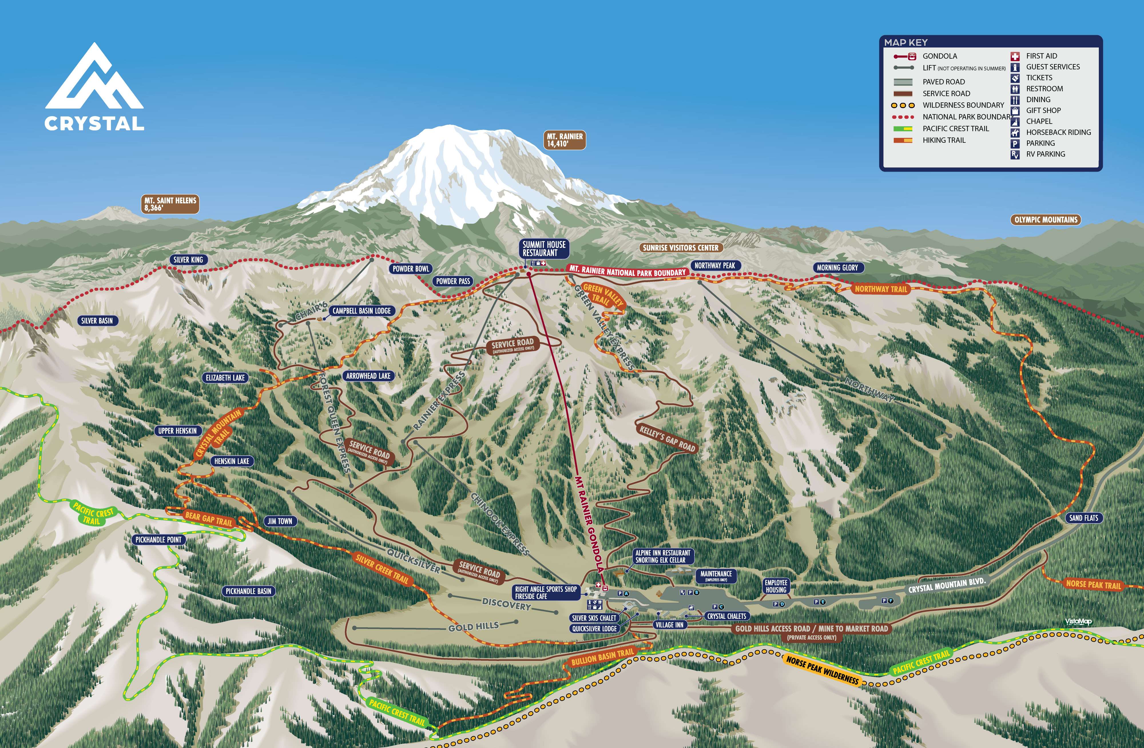
CRYSTAL MOUNTAIN HIKING TRAILS
rich-text, responsive-table
rich-text, responsive-table
Bullion Basin Trail #1156
Park in the lot at Crystal Mountain, start at the Summer Trail Map sign above the Chapel. Hike about ¼ mile straight up the short but steep Gold Hills Road. From there, the trail climbs 1.4 miles through moderate subalpine forest crossing a bridge over a stream where your furry friends can drink. Continue gaining elevation up easy switchbacks, intersecting de-commissioned ski runs from the 1970’s. Once in the Basin, the trees open to a grassy meadow with meandering streams that may be marshy early season. From this point, the trail becomes much steeper and challenging, reaching the Pacific Crest Trail at the ridge in about .8 miles.
Difficulty: Bottom / Top
/ Top  rich-text, responsive-table
Park in the lot at Crystal Mountain, start at the Summer Trail Map sign above the Chapel. Hike about ¼ mile straight up the short but steep Gold Hills Road. From there, the trail climbs 1.4 miles through moderate subalpine forest crossing a bridge over a stream where your furry friends can drink. Continue gaining elevation up easy switchbacks, intersecting de-commissioned ski runs from the 1970’s. Once in the Basin, the trees open to a grassy meadow with meandering streams that may be marshy early season. From this point, the trail becomes much steeper and challenging, reaching the Pacific Crest Trail at the ridge in about .8 miles.
Difficulty: Bottom
Distance
2.5 Miles
Elevation Gain
2100 Feet rich-text, responsive-table
2.5 Miles
Elevation Gain
2100 Feet rich-text, responsive-table
Silver Creek Trail #1192
This popular trail leads to the remote Henskin Lake, prime for fly-fishing or taking a nap in the afternoon sun. Park in the lot at Crystal Mountain and start at the Summer Trail Map sign above the Chapel. Hike up the short steep Gold Hills Road above the Chapel for about ¼ mile. From there, follow the wide trail traversing past a decommissioned avalanche control gun tower. Cross the Gold Hills ski run, under the chair. You will come upon an old gold mine on the steep bank where you will then cross a bridge over a river. Continue up a moderate incline with a few narrow and rocky sections. Upon the stream crossing, follow the sign right to Henskin Lake, taking care while stone-stepping over the water. After another ½ mile you will reach the lake at 5,480 feet, where the sun shines on the shallow water, home to small Brook Trout. Please keep dogs leashed and enjoy the peaceful alpine lake.
Difficulty:
rich-text, responsive-table
This popular trail leads to the remote Henskin Lake, prime for fly-fishing or taking a nap in the afternoon sun. Park in the lot at Crystal Mountain and start at the Summer Trail Map sign above the Chapel. Hike up the short steep Gold Hills Road above the Chapel for about ¼ mile. From there, follow the wide trail traversing past a decommissioned avalanche control gun tower. Cross the Gold Hills ski run, under the chair. You will come upon an old gold mine on the steep bank where you will then cross a bridge over a river. Continue up a moderate incline with a few narrow and rocky sections. Upon the stream crossing, follow the sign right to Henskin Lake, taking care while stone-stepping over the water. After another ½ mile you will reach the lake at 5,480 feet, where the sun shines on the shallow water, home to small Brook Trout. Please keep dogs leashed and enjoy the peaceful alpine lake.
Difficulty:
Distance
2.3 Miles
Elevation Gain
1480 Feet rich-text, responsive-table
2.3 Miles
Elevation Gain
1480 Feet rich-text, responsive-table
Henskin to Bear Gap Trail #1193
This short, steep and rocky trail starts from the South side of Henskin Lake. Heading East, climb a steep uphill to Bear Gap on the Pacific Crest Trail. From there, trails continue if you are inclined to continue the adventure. Head straight for the moderately steep Bear Gap Trail #976, going for another 2.7 miles, 1,000 feet down the East side to Hwy 410. If you have a car shuttle, turn right (South) for an easy 5 miles past Sheep Lake to Chinook Pass. *Green Trails or Forest Service map required in this area to avoid misdirection.
Difficulty:
rich-text, responsive-table
This short, steep and rocky trail starts from the South side of Henskin Lake. Heading East, climb a steep uphill to Bear Gap on the Pacific Crest Trail. From there, trails continue if you are inclined to continue the adventure. Head straight for the moderately steep Bear Gap Trail #976, going for another 2.7 miles, 1,000 feet down the East side to Hwy 410. If you have a car shuttle, turn right (South) for an easy 5 miles past Sheep Lake to Chinook Pass. *Green Trails or Forest Service map required in this area to avoid misdirection.
Difficulty:
Distance
0.7 Miles
Elevation Gain
360 Feet rich-text, responsive-table
0.7 Miles
Elevation Gain
360 Feet rich-text, responsive-table
Crystal Mountain Trail #1163
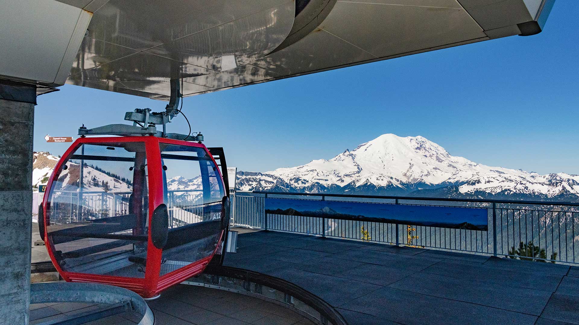
This exciting and challenging trail starts from Henskin Lake and ends at the summit of Crystal Mountain. From Henskin Lake, meander uphill through sub-alpine forest crossing winter ski runs, creeks and ponds. For those with the energy for extra distance, there are one-way side trips to Upper Henskin Lake and Elizabeth Lake at about ¼ mile up. Exit the South side of the ski area on the narrow and steep trail across the cliffs of Bear Pits. This can be a challenging section. Open up to verdant Powder Bowl with whistling marmots and abundant wildflowers. Continue up a section of the Service Road to gain the summit ridge and admire majestic Mt. Rainier up close. This road leads you to the Green Valley chair, where you take a hairpin turn to get to the Mt. Rainier Gondola, or Summit House for lunch at the end of a big adventure.
Difficulty: rich-text, responsive-table
This exciting and challenging trail starts from Henskin Lake and ends at the summit of Crystal Mountain. From Henskin Lake, meander uphill through sub-alpine forest crossing winter ski runs, creeks and ponds. For those with the energy for extra distance, there are one-way side trips to Upper Henskin Lake and Elizabeth Lake at about ¼ mile up. Exit the South side of the ski area on the narrow and steep trail across the cliffs of Bear Pits. This can be a challenging section. Open up to verdant Powder Bowl with whistling marmots and abundant wildflowers. Continue up a section of the Service Road to gain the summit ridge and admire majestic Mt. Rainier up close. This road leads you to the Green Valley chair, where you take a hairpin turn to get to the Mt. Rainier Gondola, or Summit House for lunch at the end of a big adventure.
Difficulty:
Distance
2.5 Miles
Elevation Gain
1400 Feet
(Silver Creek Trail + Crystal Mountain Trail total from base to summit: 4.9 miles - 2,500 feet elevation gain) rich-text, responsive-table
2.5 Miles
Elevation Gain
1400 Feet
(Silver Creek Trail + Crystal Mountain Trail total from base to summit: 4.9 miles - 2,500 feet elevation gain) rich-text, responsive-table
Green Valley to Kelly's Gap Trail
A great out-and-back trail from the top to the base of Green Valley*. Ride the gondola up and head down the ridgeline to the top of the Green Valley chairlift to begin this trail. Cross underneath the chair and head towards Rinky Dink Pass. Admire the great view of the mountains to the north. Meander down Green Valley to meet Kelly’s Gap Road where this trail ends.
*There is the option to continue down along Kelly’s Gap Road to the base, however it is not recommended due to the nature of this rocky, unstable Service Road.
Difficulty: Green Valley / Kelly's Gap
rich-text, responsive-table
A great out-and-back trail from the top to the base of Green Valley*. Ride the gondola up and head down the ridgeline to the top of the Green Valley chairlift to begin this trail. Cross underneath the chair and head towards Rinky Dink Pass. Admire the great view of the mountains to the north. Meander down Green Valley to meet Kelly’s Gap Road where this trail ends.
*There is the option to continue down along Kelly’s Gap Road to the base, however it is not recommended due to the nature of this rocky, unstable Service Road.
Difficulty: Green Valley
Distance
3.3 Miles
Elevation Loss
2,500 Feet rich-text, responsive-table
3.3 Miles
Elevation Loss
2,500 Feet rich-text, responsive-table
Northway Trail #1163
Ride the gondola up and start from the scenic summit ridge. This is a long, exciting descent for good knees. Cross the ridgeline and follow the trail to the north. Descend through alpine shrub, then pass through second growth and scattered old growth subalpine forests skirting the edge of Mt. Rainier National Park. Catch peak-a-boo views of majestic Mt. Rainier. Continue down the trail with some technical sections that are narrow and steep. Finish at the Lower Northway parking area. To get back to the main base parking lot at Crystal Mountain, drive or walk back up about 2 miles on the Service Road.
Difficulty:
rich-text, responsive-table
Ride the gondola up and start from the scenic summit ridge. This is a long, exciting descent for good knees. Cross the ridgeline and follow the trail to the north. Descend through alpine shrub, then pass through second growth and scattered old growth subalpine forests skirting the edge of Mt. Rainier National Park. Catch peak-a-boo views of majestic Mt. Rainier. Continue down the trail with some technical sections that are narrow and steep. Finish at the Lower Northway parking area. To get back to the main base parking lot at Crystal Mountain, drive or walk back up about 2 miles on the Service Road.
Difficulty:
Distance
6.0 Miles
Elevation Loss
2500 Feet rich-text, responsive-table
6.0 Miles
Elevation Loss
2500 Feet rich-text, responsive-table
Norse Peak Trail #1191
Park front-in on Crystal Mountain Blvd pull-out, across the street from Gold Hills Road with the yellow gate. This is a fire lane; do not park here. The trailhead is about 200 feet up Gold Hills Road on the left where you will begin up to Norse Peak. This is a difficult and steady climb with steep switchbacks to gain elevation through the sunlit subalpine forest. Pass through the burned remains from the 2017 Norse Peak fire, where wildflowers will abound in season. Turn right at the saddle at the top, where another trail descends to the Pacific Crest Trail on the East side of the crest. Follow the ridge trail up and to the left to reach the true summit. In Norse Peak Wilderness, mountain bikes are not allowed. Enjoy views across the valley of Crystal Mountain with Mt. Rainier towering in the background.
Difficulty:
rich-text, responsive-table
Park front-in on Crystal Mountain Blvd pull-out, across the street from Gold Hills Road with the yellow gate. This is a fire lane; do not park here. The trailhead is about 200 feet up Gold Hills Road on the left where you will begin up to Norse Peak. This is a difficult and steady climb with steep switchbacks to gain elevation through the sunlit subalpine forest. Pass through the burned remains from the 2017 Norse Peak fire, where wildflowers will abound in season. Turn right at the saddle at the top, where another trail descends to the Pacific Crest Trail on the East side of the crest. Follow the ridge trail up and to the left to reach the true summit. In Norse Peak Wilderness, mountain bikes are not allowed. Enjoy views across the valley of Crystal Mountain with Mt. Rainier towering in the background.
Difficulty:
Distance
6.0 Miles
Elevation Gain
2885 Feet rich-text, responsive-table
6.0 Miles
Elevation Gain
2885 Feet rich-text, responsive-table
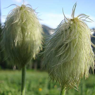
Wildflowers at Crystal
Below is a listing of common wildflowers found on the trails and meadows around Crystal. How many have you found?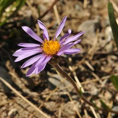
Alpine Aster rich-text, responsive-table
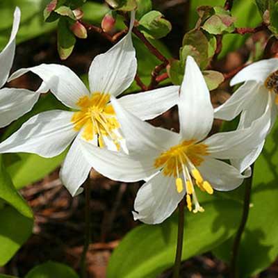
Avalanche Lily rich-text, responsive-table
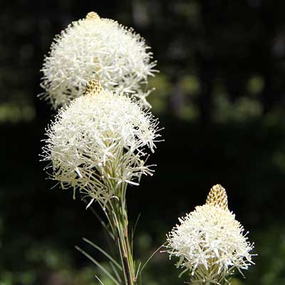
Beargrass rich-text, responsive-table
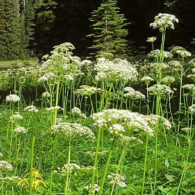
Gray's Lovage rich-text, responsive-table
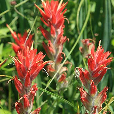
Paintbrush rich-text, responsive-table
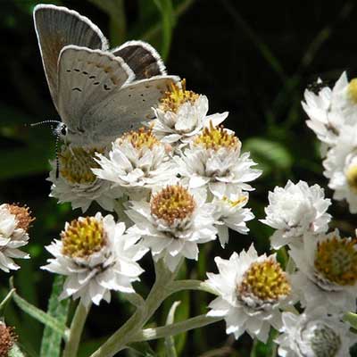
Pearly Everlasting rich-text, responsive-table
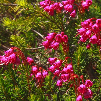
Pink Mountain Heather rich-text, responsive-table
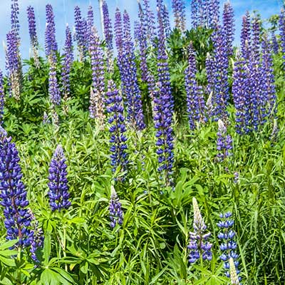
Purple Lupine rich-text, responsive-table
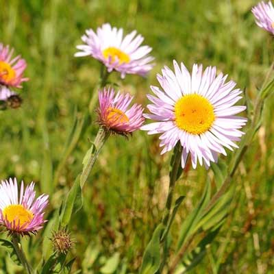
Subalpine Daisy rich-text, responsive-table

Tiger Lily rich-text, responsive-table
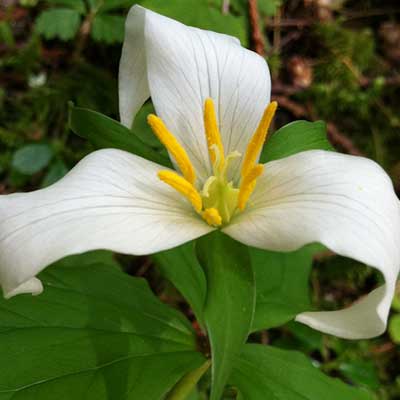
Trillium rich-text, responsive-table
Western Anemone rich-text, responsive-table